What is Earth Observation?
You may have read the project title and wondered what Earth Observation is?
Earth observation, generally referred to as EO, is the collection, analysis and presentation of data about the Earth. The data can be collected by instruments on land, in the oceans, in the air on planes or in space with satellites; or by people taking measurements or recording what is happening on the ground.
In our project, we are going to be using satellites orbiting the Earth to collect the data we use and use people on the ground in Kenya to make sure we understand what the satellite is seeing. Satellites can collect data in a variety of ways:
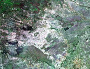
Optical instruments can collect data from the visible light and invisible infrared bands. The visible bands allow us to produce images of the same type as you would see if you were high above the Earth.
For example, the image on the left is of Nairobi in Kenya, and you can see the colours you would expect. The centre of the image is Nairobi city and it is full of urban buildings, you can see a number of water bodies as the dark black shapes and various patches of green vegetation. This image was acquired by an optical instrument onboard the Sentinel-2B satellite from the European Space Agency at the end of last year.
Optical instruments produce great images and you can extract a lot of data from those images. However, they have two key limitations. Firstly, they need to be able to see the point on Earth they are imaging, so they can’t see through clouds or smoke. This does mean it is often difficult to get completely clear images like this one. Secondly, they need light to operate and so they cannot take images at night.
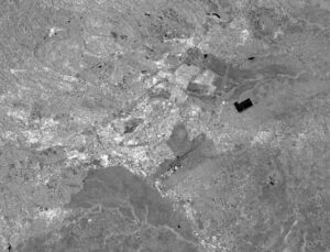
This is where radar instruments come in. They collect data by measuring microwave pulses, and are not affected by clouds or daylight. The images they collect are black and white, and so the image on the right is the same as place as the optical one but this is a radar image acquired by the instrument onboard Sentinel-1B. Some of the features of the landscape, such as the roads, are much easier to see on this image than on the optical one. This ability to use different instruments allows us to detect things that sometimes the eye cannot see! If you would like to interactively see these images they are available via a simple interface where you can switch the two layers on and off and roam around.
The other big advantage of satellites is that we can go back in time! As satellite data has been collected, and stored, since the early 1970s, it is possible to go back and have a look how an area has changed over time – in some cases, we can go back almost 50 years.
This means that we see, and measure, the changes in an environment and will help the project understand what is happening now, and in the past, with sand mining in Kenya.