EO4SAS Project
This is a brief history of Earth Observation For Sustainable Aggregate Supply (EO4SAS) project, its purpose, its achievement and its future.
Beginnings
E04SAS began as a project established through funding from the UK Space Agency (UKSA) International Partnership Programme (IPP) and brought together a Consortium of UK and Kenyan organisations, working with the Government of Kenya. This was a Discovery Phase project which ran for nine months from July 2020 to March 2021.
Aim of Discovery Phase Project
To demonstrate the feasibility of using Earth Observation (EO) techniques as the basis of a sand and aggregate management system in Kenya
and the usability and acceptance of such a service.
The Discovery Phase focused on establishing an understanding of the current baseline of sand management, gathering user requirements, and exploring a prototype resource management solution using Earth Observation (EO) satellite data.
Often thought of as plentiful, sand is not recognised as a strategic resource by many countries, including Kenya, and getting accurate information on sand is challenging. However, it is a vital resource and is the world’s second most-used raw material after water. Globally, sand extraction accounts for for 85% of all mineral extraction activities. Sand is currently being used much faster than it is being created, and should be considered a finite resource. Demand for sand is forecast to grow in the coming years through increasing population and urbanisation.
There is currently a lack of a global monitoring system for sand and aggregate extraction, and the project aimed to determine whether EO data could, alongside other information, provide insights to help the management and monitoring of sand extraction activities.For this project, we focused on sand, but the longer-term aim is to understand wider global aggregate sustainability.
Why Kenya?
Kenya was chosen for this work as Nairobi is a major hub for construction with sand mining concentrated from within the adjacent counties of Makueni, Machakos, Kitui and Kajiado, which helped focus the project’s activities to specific areas. There were reported social and environmental issues impacting on the fragile local riverine and coastal ecosystems, and potential issues caused by enhanced erosion of riverbanks, destruction of farmland, lowering of water tables and an increase in waterway turbidity that in turn exacerbates the impact of droughts.
Kenya’s construction sector’s consumption of sand and aggregates is rapidly increasing due to a major infrastructure programme of road and rail building and rapid urbanisation, and like in many parts of the world sand extraction in the country was not fully understood with varying regulatory systems across the different counties. When an internal ban on sand exporting was in force in 2018, sand prices rose by 30% within a few weeks in Nairobi, construction works were put on hold risking developers turning to unmanaged extraction sites to meet their demand.
Providing Kenya with a resource management and monitoring tool will ensures the long-term sustainability and efficient use of its sand supply.
Why a Solution Based on Satellite Technology
Satellite EO data offers an opportunity to review and monitor vast areas each time the satellites pass overhead. The project used free-to-access data from the Copernicus Sentinel -1 (Synthetic Aperture Radar) and -2 (optical) twin satellites constellations, which capture new images of Kenya every few days. This data would be very difficult to acquire by a traditional land-based survey because of the scale and distribution of activities, and hence the significant time required. Although free-to-access data offers a strong starting point for a long sustainable system we recognise that commercial data may be required alongside this to improve either the spatial resolution or the frequency of images.
EO4SAS Solution
Overview
The EO4SAS solution takes advantage of EO data to provide a unique insight into the sand and aggregate resources and process and activities of extraction allow governing organisations to plan, monitor, conserve and utilise their sand resources.
The image below shows how the data provided by EO4SAS integrates into the wider Kenya resource management governance processes and systems.
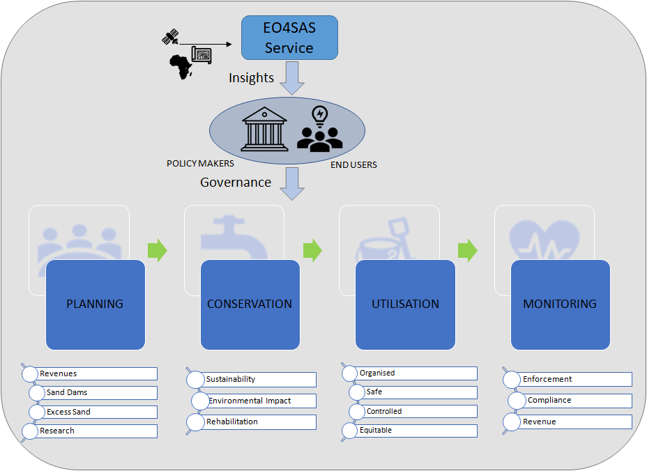
EO4SAS processes satellite data (e.g., free-to-user Copernicus data) and data from other sources through a variety of bespoke products to present users with sand resource management insights presented through a variety of user interfaces.
EO4SAS Target Users
We see two direct target user groups, with different specific needs:
- Government as a policymaker, planner and regulator to support governance through policies, a planning and regulatory regime and mitigation strategies associated with long-term supply. Within counties, there will be similar requirements at local levels.
- Investors, extraction industry and construction industry by ensuring a sustainable supply chain, including potentially sustainable sourcing certification, to support construction projects and growth that will attract foreign and supports internal investment.
EO4SAS Benefits
We provide information and governance tools to create knowledge on sustainable sand mining to ensure the needs of the present are met without compromising future generations ability to live and meet their own need. The major benefits of EO4SAS are:
- Coverage area is vast – far greater than could easily be covered by land-based means;
- Imagery and insights are updated regularly and frequently (2-5 days);
- A vast amount of historic data is available – allows in-depth trend analysis starting many years ago
- Observation is unobtrusive / non-invasive
You can read in more detail by following these links:
Short Project Presentation describing the work and how satellite data might be able to support the project.
Project Partners involved in the project.
Press Release launching the project.